NASA has a comprehensive website where you can view landmark photographs from all over the world. The following images demonstrate the impact humans have had on these landscapes, for better and for worse, over the past 5-100 years.
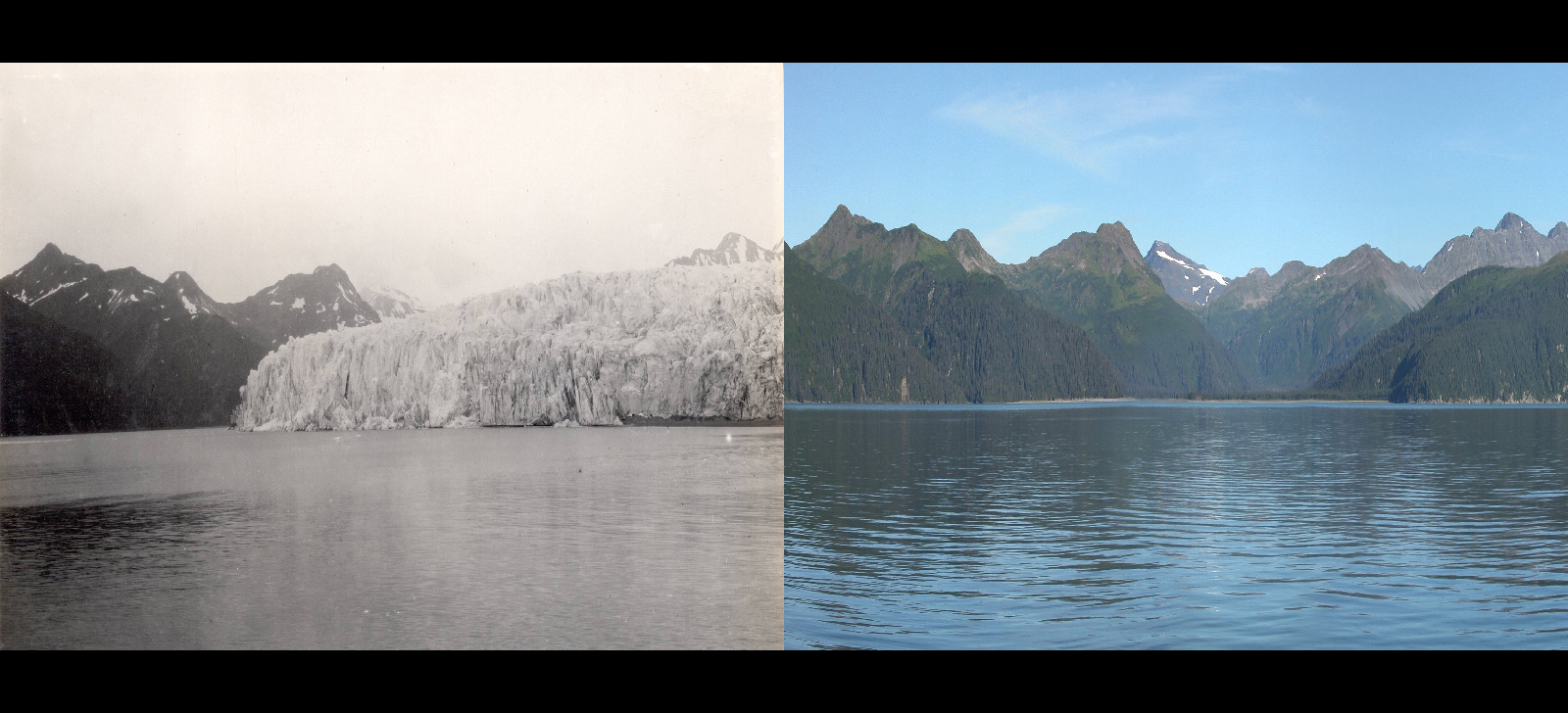
Pedersen Glacier, Alaska. Summer, 1917 — Summer, 2005.

Pedersen Glacier, Alaska.
These photographs, taken from the same location on the western shoreline of Aialik Bay in Alaska. As seen in the first photograph, the bay is covered in icebergs. In the second photo, taken in the summer of 2005, the icebergs have vanished.
Aral Sea, Central Asia. August, 2000 — August, 2014.

The Aral Sea is located in Central Asia, between southern Kazakhstan and northern Uzbekistan. For 600 years, until the last quarter of the 20th century it was the world’s largest saline lake. In 1906, the Soviets diverted the two rivers that fed into the Aral Sea. This caused the lake to dry up, as seen in the second photograph taken in 2014.
Lake Oroville, California. July, 2010 — August, 2016.

Lake Oroville is a reservoir formed by the Oroville Dam, which impounds the Feather River. The Oroville Dam is the second largest in California. The flow of water was halted in 2016 when state officials discovered a massive hole in the dam’s concrete wall. Despite stopping the flow of water, tributaries flooded the area, causing record damage.
Carroll Glacier, Alaska. August, 1906 — September, 2003.

Carroll Glacier, which is 15 miles long, is located in Glacier Bay National Park and Preserve in Alaska. The first photograph shows the glacier in 1906. The second image reveals how far the debris-covered glacier has retreated and thinned.
Powell Lake, Arizona and Utah. March, 1999 — May, 2014.

Lake Powell, a reservoir on the Colorado River, is situated on the border of Utah and Arizona. It is a major vacation spot . The area has suffered frequent droughts over the last two decades.
Bear Glacier, Alaska. July, 1909 — August, 2005.


Bear Glacier originates at the Kenai Fjords National Park, and is the longest glacier in the Alaskan park, measuring 13 miles long. Bear Glacier is largely inaccessible, therefore research on its conditions is done through long-distance and satellite photographs.
Forests in Rondonia, Brazil. June, 1975 — August, 2009.

Deforestation is a key ecological issue throughout South America. The land in the photographs is in Rondonia. The first photo shows the ground completely covered by forests. In the second photograph taken in 2009, nearly all of the forest has been destroyed.
McCarty Glacier, Alaska. July, 1909 — August, 2004.

The McCarty Glacier, a tidewater glacier is located in the Harding Icefield in the Kenai Mountains of the Kenai Peninsula. There is a marked difference in the amount of ice and snow seen in 1909 versus 2004.
The Dasht River, Pakistan, August, 1999 — June, 2011.

The Mirani Dam is located across the Dasht River in the Central Makran Range in Pakistan. The first photograph shows how the river flowed before the dam was built. The 2011 image shows how the dam has positively impacted the area. It has helped bring agricultural irrigation water to the surrounding areas and has also provided drinking water for local residents.
Matterhorn Mountain in the Alps, on the border between Switzerland and Italy. August, 1960 — August, 2005.

The Matterhorn is the legendary mountain of the Alps, surrounding the main watershed and border between Switzerland and Italy. Little has changed between 1960 and 2005, other than a small decrease in snow at its tips.
Mabira Forest, Uganda. November, 2001 — January, 2006.

The Mabira Forest which is 300 square kilometres is located in Uganda. This forest helps maintain a wet climate so that farmers can grow sugarcane.
Toboggan Glacier, Alaska. June, 1909 — September, 2000.

This 1905 photograph of Toboggan Glacier shows that it was thinning and retreating, surrounded by a large and barren bedrock zone. The 2000 photograph shows that the retreating of the glacier is accelerating.
Great Man-Made River, Libya, April, 1987 — April, 2010.

The Great Man-Made River in Libya is called the greatest irrigation project in the world. It supplies water to the Sahara Desert. The network of pipes, aqueducts and wells runs more than 500 metres deep.
Qori Kalis Glacier, Peru. July, 1978 — July, 2011.

The Qori Kalis Glacier is a rare thing – an actual tropical glacier. It is located in the Cordillera Oriental section of the Andes mountains of Peru.
Mar Chiquita Lake, Argentina. July, 1998 — September, 2011.

The Mar Chiquita is the largest salt lake in South America. It is 45 miles long and 15 miles wide. The more recent photo shows how the lake has decreased in size.
Muir Glacier, Alaska. August, 1941 — August, 2004.

Muir Glacier is located in Glacier Bay National Park and Preserve in Alaska. Scientists have documented the retreat of the glacier due to warming temperatures. The glacier has retreated by more than 31 miles in 100 years.
Uruguay Forests, March, 1975 — February, 2009.

Uruguay has been proactive regarding deforestation. These photos show that the forested area has actually increased from 45,000 hectares to 900,000 hectares.
- Tags:
- climate change
- earth
- science

Twenty years from now you will be more disappointed by the things that you didn’t do than by the ones you did do. Sail away from the safe harbor.